Results 1 to 14 of 14
-
2020-09-29, 05:27 AM (ISO 8601)Titan in the Playground


- Join Date
- Apr 2009
- Location
- Germany
 Geography: Settlement pattern on the North American Pacific Coast
I just spotted a curious phenomenon on population density maps of the United States.
With the exceptions of Los Angeles and San Francisco, it seems like basically all major population centers are located on a line running parallel to the Pacific coast, about 100 to 150 km inland.
Spoiler
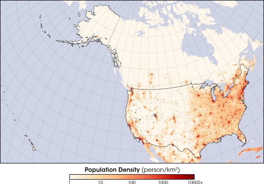
Obviously that's also where the highway and rail line goes. In Europe I would assume that these were build because that's where the cities are, but in this case could it be that the cities were build in these places because they have close access to existing transportation? Or does this have something to do with the landscape and environment of the region?We are not standing on the shoulders of giants, but on very tall tower of other dwarves.
Spriggan's Den Heroic Fantasy Roleplaying
-
2020-09-29, 06:02 AM (ISO 8601)Ogre in the Playground

- Join Date
- Aug 2013
Re: Geography: Settlement pattern on the North American Pacific Coast
It has everything to do with landscape and environment. When were all these cities built? I am willing to bet a lot they were all built before highways (around 1930s) and many before railroads (1850s ish). At least major urban areas. Cities are normally built for a reason in a spot where they can be supported by the surrounding environment, this was true well into modern times. Originally Posted by Yora

Heck if you look at your second map you can see 2 bands of population density in California. 1st is along the coast, no big surprise. The other is abit inland because it follows the geographical feature of the landscape, "the valleys", I'm not local but I think it is somehow a thing. Between those you have areas of raised ground that didn't use to be useful for human habitation. And population concentration tends to follow established patterns.
As far as I know the geography of the pacific coast almost entirely is backed by the rocky mountains or other areas of geography thats rather hostile to human habitation. If you look at a satellite map you will see the green parts of the pacific coast raches about 200-300km inland. Also effectively, the land rises up from the coast towards the mountains inland which makes it easier to build stuff, so human habitation tends to hug the coasts. And success breeds success. If you got a big town you expand that, you don't go building an entirely new one. Normally.
I think you will find all major urban concentrations also lie close to the sea. This is particularly important in the pacific area as there was no other economical way to reach it beyond ocean travel for centuries. This is generally true for most other places as well. Very few population centers exist away from navigabel watercourses for this reasons. Even then I am willing to again bet 100% of those have fresh watersource of some kind. Again the sole exception being modern created urban areas where this is solved "artificially".
Some cities have been created due to modern transportation links, no doubt, and e.g. the railways of the 1800s definitely created these and changed the layotu of important towns. Though ironically few of these survived into modern times as railways fell in importance as transport links.
I fail to quite see what you are getting at though... Los Angeles and San Francisco hug the pacific coast (they are both major port cities) every bit as tightly as any other urban area on the western coasltine.Last edited by snowblizz; 2020-09-29 at 06:09 AM.
-
2020-09-29, 06:14 AM (ISO 8601)Titan in the Playground
- Join Date
- Apr 2009
- Location
- Germany
Re: Geography: Settlement pattern on the North American Pacific Coast
What I am curious about is this 100km strip of very low population that runs between the coastal cities and the inland cities.
We are not standing on the shoulders of giants, but on very tall tower of other dwarves.
Spriggan's Den Heroic Fantasy Roleplaying
-
2020-09-29, 07:01 AM (ISO 8601)Bugbear in the Playground

- Join Date
- Feb 2015
Re: Geography: Settlement pattern on the North American Pacific Coast
That's largely a set of mountains, called the Pacific Coast Ranges, or just the Coast Range. Not so attractive for agriculture. Originally Posted by Yora
-
2020-09-29, 07:04 AM (ISO 8601)Troll in the Playground

- Join Date
- Mar 2012
- Location
- UK
- Gender

Re: Geography: Settlement pattern on the North American Pacific Coast
Something to bear in mind is that pretty much every major city on the planet is on a major river, usually one that used to be navigable. (I understand that Madrid is one of the notable exceptions.)
If you add things like rivers to your map, not to mention the aforementioned mountain range things will become a lot clearer.
-
2020-09-29, 07:49 AM (ISO 8601)Titan in the Playground
- Join Date
- Apr 2009
- Location
- Germany
Re: Geography: Settlement pattern on the North American Pacific Coast
Oh yes, would you look at that.
Spoiler: Elevation map
There are two green stripes of low lying land where the towns are located. And of course the water drains down the middle of those. You can clearly the see the high elevation where there's a gap in town concentration around the border between California and Oregon.
Interesting topography. Probably has something to do with the subduction of the Pacific Plate.
In South America, the oceanic plate is moving straight east under the continental plate, resulting in a single mountain range in form of the Andes, without a secondary range between the coast and the lowlands.
In North America, the the plates are sliding along each other one going north and the other south. That probably has something to do with the formation of the Coast Ranges and Baja California.Last edited by Yora; 2020-09-29 at 07:52 AM.
We are not standing on the shoulders of giants, but on very tall tower of other dwarves.
Spriggan's Den Heroic Fantasy Roleplaying
-
2020-09-29, 09:08 AM (ISO 8601)Colossus in the Playground

- Join Date
- Feb 2007
- Location
- Manchester, UK
- Gender
Re: Geography: Settlement pattern on the North American Pacific Coast
I'd have to disagree there. Before the construction of the Panama Canal, the only ways to reach the Pacific coast from Europe or the East Coast via sea would be to go all the way round Cape Horn or else go eastward across the entire Pacific--this is why people were so desperately searching for the fabled North-West Passage, because it would make the journey that much easier. So there wasn't actually such a huge difference between the ease of travel overland and via sea, which might explain why those cities in the north-west are 150km inland--they were founded in the first place settlers reached after travelling the Oregon Trail, not where people landed from the sea. Originally Posted by snowblizz
-
2020-09-29, 10:36 AM (ISO 8601)Banned
- Join Date
- Feb 2013
Re: Geography: Settlement pattern on the North American Pacific Coast
Note that the population cluster in Washington state is around the shore of Puget Sound. Portland is a ways inland because the tides meant that was where the port would be (the mouth of the Columbia River is still one of the worst navigation hazards in the Western Hemisphere).
The Pacific Plate is offshore for most of North America, btw. The fault line basically runs from the Gulf of California to San Francisco Bay.
-
2020-09-29, 11:41 AM (ISO 8601)Titan in the Playground

- Join Date
- Oct 2010
- Gender
Re: Geography: Settlement pattern on the North American Pacific Coast
It's: Originally Posted by Yora
1. A rainforest and a mountain range.
2. Government land.
The pacific states are all heavily government owned (like 40% of the good land mass) and the other part is majority desert. This protected timber production, but it also meant of the 1/3 of Oregon and 2/3 of Washington and California that actually can hold populations, half of it or more is government land. Originally Posted by The Glyphstone
-
2020-09-29, 02:52 PM (ISO 8601)Troll in the Playground
- Join Date
- Jul 2015
Re: Geography: Settlement pattern on the North American Pacific Coast
Pacific Coast Settlements mostly track geography, specifically the valleys where there was and is enough water and proper soil to support agriculture. California's inland population is therefore concentrated in the Central Valley, which combines the San Jaoquin and Sacramento Valleys. Even Los Angeles is located in a valley, the San Fernando, though it's long since been urbanized. Oregon's population is likewise concentrated in the [url=https://en.wikipedia.org/wiki/Willamette_ValleyWillamette Valley[/url], which runs from Eugene to Portland.
Washington State partially breaks this pattern, due to the geography of Puget Sound, but there's still a pattern of settlement in the valleys further north, both in the smaller Skagit and larger Fraser Valley. The latter extends into Canada and contains Vancouver BC. If you were to somehow close the Strait of Georgia and Salish Sea by extending Vancouver Island a little further north and south the Washington State pattern would subsequently resemble that of Oregon as well.
The federal government actually owns very little of the Pacific Coast. US federal land in the three Pacific Coast states is concentrated in inland areas, primarily the Cascades and Sierra Nevada mountain ranges and a lot of high desert in eastern Oregon (also several large Native American reservations which count as 'federal land' for complex legal reasons). The major 'coastal' plots of federal land are Olympic National Park and the Rogue River National Forest in southwestern Oregon, both of which are extremely rugged areas unsuited for human habitation. Originally Posted by Tvtyrant
-
2020-09-29, 03:36 PM (ISO 8601)Titan in the Playground
- Join Date
- Oct 2010
- Gender
Re: Geography: Settlement pattern on the North American Pacific Coast
Originally Posted by Mechalich
Spoiler
I'm not going to get into a debate because it could easily turn political, but I'll link the picture of what the government owns in Oregon for perusal. Originally Posted by The Glyphstone
-
2020-09-29, 04:25 PM (ISO 8601)Titan in the Playground


- Join Date
- Feb 2008
- Location
- Texas
- Gender
Re: Geography: Settlement pattern on the North American Pacific Coast
That actually helps clarify why it's so hard (in the trucking business) to get everything in Oregon that's not Portland serviced. CA north of Sacramento is a really tough region too.
-
2020-09-29, 06:49 PM (ISO 8601)Ogre in the Playground

- Join Date
- Feb 2005
- Location
- Santa Barbara, CA
- Gender
Re: Geography: Settlement pattern on the North American Pacific Coast
Firstly it helps to remember San Francisco is about in the middle of California north south wise. Also settlement was originally focused in the areas were agriculture was easiest. Notable the Sacramento basin with the associated port of San Francisco. and the Willamette Valley (via your Oregon Trail). And basically all the land south of San Francisco is basically desert or semi desert...water management such as the California aqueduct) is a huge deal here. Also the crossing from the pacific can be rough. There are few good anchorages and most ships had to come from a long way though bad conditions. So protected ports were at a huge premium and thus protected areas Puget Sound, as far up the Columbia as you navigate, San Francisco Bay, and the area protected by the Santa Barbara channel islands (which includes much of Southern California) which had a number of well protected bays itself (two especially large)...Which led to the development of Seattle/Tacoma, Portland, San Francisco Bay, Los Angeles (Northern Bay-behind-barrier Islands), and San Diego (Southern Bay behind barrier Islands) which are today still the major centers of population you'll see on that map.
Southern California was basically dominated by ranchland for a LONG time. Where I am is pretty much the boarder culturally between SoCal and Norcal (I'm where the mountains that cut of the bottom of the big central valley hit the coast) in large part because the Transverse Mountains (truly the area I call home...the towns and coast are fine but I'm a mountain person) are brutally rugged but also they were bandit country basically up to the dawn of the 20th century...they preyed on gold coming south to pay for cattle drives going north. It did eventually change, the southern California agricultural industry really thrive and even then it focused on specialty crops like citrus and pampas grass fronds (no kidding, they were used for interior decorating and fancy hats) that didn't grow in most of the rest of the country very well. Only with the discovery of oil, and major waterworks did things really blow up here.
-
2020-10-02, 04:36 PM (ISO 8601)Ogre in the Playground
- Join Date
- Feb 2005
- Location
- Santa Barbara, CA
- Gender
Re: Geography: Settlement pattern on the North American Pacific Coast
[QUOTE=sktarq;24731702]Firstly it helps to remember San Francisco is about in the middle of California north south wise. Also settlement was originally focused in the areas were agriculture was easiest. Notably the Sacramento basin with the associated portage off the San Francisco Bay, and the Willamette Valley (via your Oregon Trail). And really the coast ranges are harder to live in the shadow of. They do not hold significant snowpack to have meltwaters well into summer across most of their length. The Sierra Nevada (south) and the Cascades (north) do hold enough snow for reliable water most of the year. So populations tended to hug the east side of the broad Central valley
And basically all the land south of San Francisco is basically desert or semi desert...water management (such as the California aqueduct) is a huge deal here. Also the crossing from the pacific can be rough. There are few good anchorages and most ships had to come from a long way though bad conditions. So protected ports were at a huge premium and thus protected areas Puget Sound, as far up the Columbia as you navigate, San Francisco Bay, and the area protected by the Santa Barbara channel islands (which includes much of Southern California) which had a number of well protected bays itself (two especially large)...Which led to the development of Seattle/Tacoma, Portland, San Francisco Bay, Los Angeles (Northern Bay-behind-barrier Islands), and San Diego (Southern Bay behind barrier Islands) which are today still the major centers of population you'll see on that map.
Southern California was basically dominated by ranchland for a LONG time. Where I am is pretty much the boarder culturally between SoCal and Norcal (I'm where the mountains that cut of the bottom of the big central valley hit the coast) in large part because the Transverse Mountains (truly the area I call home...the towns and coast are fine but I'm a mountain person) are brutally rugged but also they were bandit country basically up to the dawn of the 20th century...they preyed on gold coming south to pay for cattle drives going north. It did eventually change, the southern California agricultural industry really thrive and even then it focused on specialty crops like citrus and pampas grass fronds (no kidding, they were used for interior decorating and fancy hats) that didn't grow in most of the rest of the country very well. And even then it was concentrated in the various basins. LA basin being the largest (basically it involved a complex of valleys that split off of each other-the San Fernando being the most famous and can be thought of the NW branch of LA smaller edge branches mean you start getting into the "canyons").
Only with the discovery of oil, and major waterworks did things really blow up here in So Cal and population is basically limited to the coastal basins to this day. Inland agriculture exists due to large scale water management (create the Salton Sea (look in the SE corner of your elevation map) from agricultural runnoff with water diverted from Colorado river as an example) but that's the Mojave Desert (and various other but the Mojave is the only part you're likely to have heard of) you're looking at

 Reply With Quote


 RSS Feeds: